NATURAL DISASTERS:
SECTION 1: PLATE TECTONICS
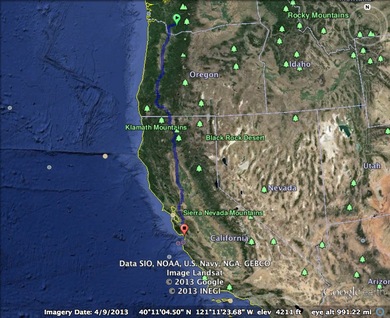
Mount St. Helens is located in the southern part of Washington; it is the Larger green marker on the map. Loma Prieta is the red marker located in central California.
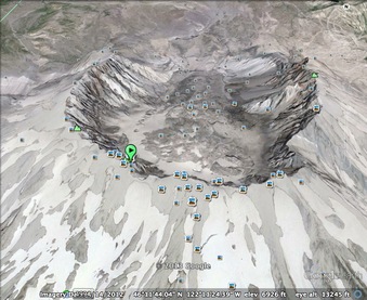
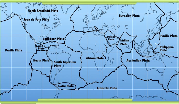
Mount St. Helens- Is formed by two slow-moving plates low-moving plates: North America tectonic plate and the Juan de Fuca tectonic plate. This lies on a convergent boundary.
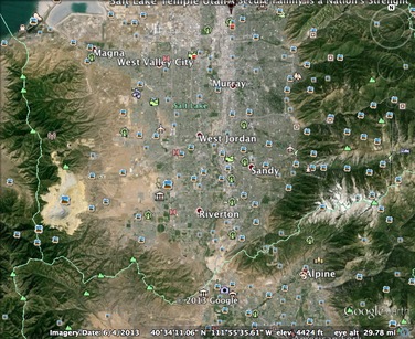
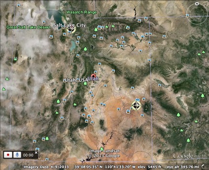
The Salt Lake City area is located between two large mountain ranges perfect for enclosing the tornado of 1999. This shows you the "bowl" like area we live in.
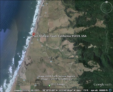
This image show where the San Andreas Fault meets the Pacific shoreline.
This image is of the Wasatch Fault line. It is about 240 miles long. We are expected to experience an earthquake with the magnitude of at least a 7.0. This would be a major catastrophic disaster.
Section 1: Plate Tectonics
Above is a Google Earth image of two tectonic hazard that occurred in the last 50 years. Mount St. Helens in the State of Washington erupted violently in 1980. The Loma Prieta earthquake in California occurred in 1989.
This assignment has opened my eyes to all of the potential hazards that exist. I love being able look at things that have happened in the past. I haven't thought much about the tornado in Salt Like since about 1999 when it really happened. It is so interesting to look back in the past and see how much we have grown from it. We have built our structures to prepare the massive earthquake that we are going to get. Society is taking precautions.
Above is a Google Earth image of two tectonic hazard that occurred in the last 50 years. Mount St. Helens in the State of Washington erupted violently in 1980. The Loma Prieta earthquake in California occurred in 1989.
- How far apart are these two points on a map? Mount St. Helens and Loma Prieta, CA are 762 miles apart. I looked it up and if you were to drive there with no traffic on the quickest route that "Siri" (or the name of your electronic personal GPS navigator) could give you it would take you about 13- 14 hours. That is if you went the speed limit and obey all traffic laws at all times.
- What are the tectonic boundaries for each of these two points? Mount St. Helens: The two plates that created the volcanic eruption were a collision of two slow-moving plates: North America tectonic plate and the Juan de Fuca tectonic plate. They are Convergent boundaries. Loma Prieta: The Pacific Plate and the North American Plate created this earthquake.They were transform boundaries.
- How could there possibly be a connection to these to catastrophic events even though they were completely different and nearly 10 years apart from each other? List reasons why there might be a connection and why there might not. Mount St. Helens and San Andreas fault the place where Loma Prieta earthquake occurred both lie in the Ring of Fire. The Ring of Fire is a place where are numerous amount of Earthquakes, and Volcanic eruptions happen in the basin of the Pacific Ocean. The Ring of Fire is always active. Even though these two catastrophes are have a time difference of about 10 years. That is but a blink of an eye for tectonic plates. That is really the only real connection I could figure. From question two we know that Mount St. Helens is on Convergent boundaries while Loma Prieta lies along transform boundaries and those are opposites of each other. So, to say that there is an absolute connection between the two is unlikely. The only true connection is that they lie in the Ring of Fire.
- Describe how these two events are different in regards to the human impact. These two catastrophes were different in so many ways in regards to humans. For starters Mount St. Helens was a Volcanic eruption. This eruption caused ash to become airborne and then land everywhere including: sewage systems, hundreds of homes and vehicles and buildings. This disaster caused severe damage to timber, civil works and travel which affected everyone. Travel was shut down temporarily. Many animals were killed from this explosion as well. Which meant hunting for many people for food supply was a definite NO! From the Loma Prieta earthquake damage was different. With this we actually had buildings and bridges collapsing with and without people in/on them. Most of the "elevated" structures became flattened and minimally lifted off the ground. This was the biggest different between the two catastrophes. Buildings and such collapsed in the shake and in the eruption things life (animals, plants etc.) were covered and several killed. We had to replant and clean ash off things from the eruption. In the shake we had to completely rebuild and clean up.
- What is the most significant natural disaster that has occurred near where you live or that might occur in your region? The Salt Lake City Tornado is probably the biggest disaster that I remember from my lifetime. I was four at the time, but I remember watching t.v. and several amber alerts were going off and talking about the tornado. My mom and I watched as the tornado swept through the city. Ruining many homes (over 100) and injuring several people. It was August and no one saw it coming, until the hail began. I lived about 45 minutes away from this terrible incident. I remember the panic my mom was in hoping my dad was away from the incident. It just happened that he wasn't near the crazy storm. I was already paranoid about the wind when I was younger and this just amplified my fear. I am not scared of wind now, but as a child this fear of tornadoes like the movie Twister was terrifying! Tornadoes are very rare in Utah because of the mountains, but it doesn't mean that they cant happen.
- What are the factors that contribute to this hazard? Geographically where Salt Lake City is located we find rapidly changing pressures and temperatures. Utah is an where one day you can have a snow storm and then the next it can be warm weather. Within the valley there is very little elevation change, so it would allow something like a tornado to build momentum. Our mountains are a type of storm containing "bowl." That is why we can hold pollution so well within our area. There has to be the "perfect" storm to really start a tornado in Utah. That is why it is so rare to find tornadoes within Utah.
- What can people in your region do to reduce their vulnerability to that hazard? We would want to reinforce the structures that we live in. Prepare ourselves with a 72 hour kits. Food storage is a huge factor and one that we all need to have stocked up. Keep medical supplies on hand and readily available. Lastly, we need to have an emergency plan in place.
This assignment has opened my eyes to all of the potential hazards that exist. I love being able look at things that have happened in the past. I haven't thought much about the tornado in Salt Like since about 1999 when it really happened. It is so interesting to look back in the past and see how much we have grown from it. We have built our structures to prepare the massive earthquake that we are going to get. Society is taking precautions.
